Polar Coordinate System
Definition
The polar coordinate system specifies a given point in the plane (see Cartesian coordinate system) by using two coordinates:
- the point's distance from a reference point called the pole,
- the point's direction from the pole relative to the direction of the polar axis, a ray drawn from the pole.
The distance from the pole is called the radius, and the angle is called the polar angle.
Interpretation
The Cartesian product supplies pairs ; different angle values can represent the same point. The trigonometric functions convert the radius and direction to Cartesian coordinates through and .
The polar coordinate system locates a point on a plane by saying how far away it is from a centre point and what angle it makes from a fixed direction.
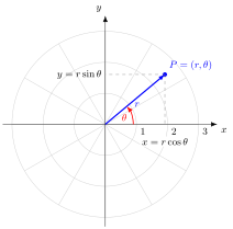
Using the 2-argument arctangent for the angle, for the nonzero point in the figure, and . Constant gives a circle and constant gives a ray of the polar grid.
Set the radius and the polar angle , or drag the point: and .
Key Results
- Conversion to Cartesian coordinates: ,
- Conversion from Cartesian coordinates: ,
Examples
- With , describes the ray from the pole at angle to the polar axis: .
- is a unit circle centred at the pole.
Prerequisites
Related Concepts
- Real Coordinate Space — a later generalization in Math III.
- 2-Argument Arctangent
Sources
- Math II: Linear Algebra · Week 1
Aliases: polar coordinates Symbols: infinity, pi, real numbers, square root, theta
Last updated: 20 October 2026 03:02
Polar Coordinate SystemPolar Representation of Complex NumbersTrigonometric FunctionsCartesian ProductReal Coordinate Space2-Argument Arctangent